More than a week has passed since a catastrophic debris flow partially buried the village of Villa Santa Lucía, X Región of Chile, killing at least 15 and cutting road access between Chaitén and Puyuhuapi. This region is characterized by extreme topographic relief, and is no stranger to the intersection of natural hazards and the human population (see the 2008 eruption of the Chaitén volcano and subsequent relocation of the village of Chaitén). The debris flow corresponded to a particularly heavy precipitation event, although at present varying interpretations have been given--authorities seem split on whether or not the trigger for the flow was glacier collapse or slope failure.
I'm just another guy with a blog on the internet, so take it for what you will, but from afar the Villa Santa Lucía debris flow reflects the instability associated with recently deglaciated landscapes.

image from t13.cl
Geologic context
Images suggest that by the time the debris flow reached the village it was mud-rich and "wet." Such events are probably the norm rather than the exception in this zone--Sergio Sepúlveda, of the University of Chile, noted that the village was built upon an ancient alluvial plain.
The flow originated from the headwaters of the Río Burritos, to the northwast Villa Santa Lucía. An obvious scarp suggests that slope failure was involved in the development of this flow. According to my copy of the Mapa Geológico de Chile (SERNAGEOMIN 2003), the scarp lies almost on top of the triple junction between arc intrusives of the Patagonian Batholith (Mg) to the south, schists and amphibolites of the Liquiñe Metamorphic Complex (PzTr4b) to the north, and a zone without information to the west. Cutting the entirety of this zone is the dextral Liquiñe-Ofqui Fault Zone (LOFZ). The sum of these factors is a zone of potentially weakened bedrock, although difficulty in access means that the area is poorly studied in relation to the rest of the country.

image from Subsecretaria del Interior
Observations
Images from the first overflights show vegetation scour approximately 100m above the current height of the river. This strongly suggests a large mass wasting event, as opposed to bank erosion from flooding, as a factor in the development of the debris flow. The bare, orange scar on the mountain above draws the eye, as do the similarly orange sediments that make up the flow.

When compared against historical imagery (2006), additional scarp development is evident, as is the presence of slump blocks, demarcated by the snowy surfaces that lie on top of the scarp and upper flow. These are signatures of a deep-seated rotational slump of bedrock.

This is supported by a comparison of photos post-event and historical GE imagery. A large section of the slope, including the peak marked by the asterisk (*), is missing.
What's additionally interesting is that, prior to the debris flow of 16 December, it appears as though there already existed a scarp of sorts, as well as a great deal of unconsolidated material originating from the orange slope. Moreover, what appear to be levee deposits flank the upper reaches of the Río Burrito. This latter piece of information is concerning; it seems as though as early as 2006 there existed signs that the area was unstable and prone to debris flow events.

Interpretations
Above is my interpretation of the geomorphology in the zone prior to the event of 16 December. I interpret the orange unconsolidated deposit as a polygenetic landform resulting from the interaction of slope processes and paleoglacial activity. I also note that the Río Burrito appears spontaneously from the older unconsolidated deposit. Its relative size suggests that it is the principal meltwater outlet of the glacier upstream. Either the entirety of the meltwater passes through the unconsolidated deposit by infiltration, or the preexisting unconsolidated deposits are at least partially ice-cored (more likely).
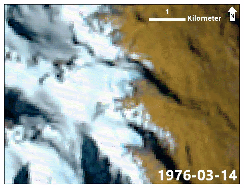
Images: false-color image composite animation from Landsat 1-5 MSS, Landsat 5 TM, Landsat 7 TM, and Sentinel-2 MSI data
I used publically-available historical satellite imagery of the zone to better constrain the geochronology of the area. The temporal coverage suffers from the poor resolution of the Landsat MSS imagery, as well as Landsat 5's international communication outage from 1987 onwards. This latter event is particularly unfortunate, as it appears as though the valley underwent significant geomorphic change between1985-1998. During this time the upvalley glacier retreated by at least 100 m, a proglacial lake formed in the recently deglaciated area, and the area of the orange deposit increased substantially. In addition, a lateral moraine that cuts the orange deposit was formed. The present altitude of this moraine over the present glacier surface suggests that the ongoing retreat since that time was also matched by significant loss of volume.
Imagery before 1985 is unfortunately unable to define details of the preexisting slump area. It appears that by 1985, at least part of the orange unconsolidated deposit existed, although it is not possible to say whether this represented purely slope deposits or an accumulation of proglacial sediment. The best available mass balance study in the area is Andrés Rivera's work further south (PDF), which shows a stillstand in cumulative mass balance of the Glaciar Chico from 1990-1993 (Fig. 6.9). This climatic event could correspond to the moraine-building event that crosscuts the orange deposit in our site, and brackets the principal deposition of the orange deposit to between 1987-1993. By 1998 the orange unconsolidated deposit had acquired its pre-flow horizontal extent.

image: oldclimber2
A local posted some photos taken of the zone in April of 2017, referenced in the AGU's Landslide Blog. Of note is the lake that has formed in the unconsolidated deposit--more evidence of sediment-mantled ice. Some smaller scarps (rightward/south-dipping in the image) are developed to skier's left of the stream, testament to the generally unstable nature of the deposit. Hard to tell from here but by the drainage developed between the deposit and the sidewall (kame terrace?) the deposit certainly looks like lateral-frontal moraine with an ice-proximal component of debris-covered dead ice. The seeming concordance of the moraine material with the bedrock of the scarp suggests that localized mass wasting was an important contributor to the construction of the moraine; furthermore, the lack of significant remobilization implies that the deposition of at least the surficial deposits postdated ice stagnation.

image: oldclimber2
The rock quality of the slope appears, in a word, bad. Hydrothermal alteration following a fractured contact would not be out of character this close to the LOFZ. Dave Petley at the Landslide Blog notes that tension cracks are readily visible near the slope edge.
I'm in general agreement with Dave's interpretation of the event:
Based on this it appears that the landslide consisted of a large volume rock slope failure that collapsed onto the colluvium and moraine at the based at the slope. The images suggest that this the debris at least partially saturated (note the spring within the deposit nprior to failure) and it may also have contained substantial amounts of ice. This deposit has mobilised to form a complex, high velocity rock avalanche / debris flow.
A few extra observations:
- Implicit evidence of slope instability in the area was available for at least a decade before the event of 16 December.
- Mass wasting events followed local glacier retreat from the base of the slope between 1985-1998.
- The peculiar hydrology of the zone strongly suggests stagnant ice in the subsurface of the moraine. In a warming climate, this is inherently unstable and is a yellow flag in a high-relief zone. Levee deposits predating 2006 indicate that sediments in the moraine were mobile.
Professionally, I've always thought that the idea of "deglacial hazards" was a bit of a crock in the sense that it's a convenient way for glaciologists to convince non-geologists to give them money to study a problem that's not actually important. Looking at this event has forced me to reconsider. Granted, slope instability isn't unique to recently deglaciated areas; supraglacial rock avalanches are a highly important supply of proglacial sediment in alpine zones. However, you look at an example like this and you have to think: is the onset of mass movement post glaciation just by chance, or is there a relationship between deglaciation and slope instability? In several of the sites where I work there are active movements occurring on recently-deglaciated slopes (e.g. 49.3276°S/73.0276°W). This relationship has also been proposed for the Pleistocene-Holocene transition, although limitations in geochronology have limited the confidence in which we can assign cause to these events.
To summarize, I see several factors that conspired to create the preconditions necessary to lead to this event:
- A glacially oversteepened bedrock slope that had recently (~1990 CE) undergone glacial retreat/debuttressing;
- Seemingly weathered and fractured slope bedrock;
- Large, unstable, ice-cored sediments that include parts at or near saturation;
- The intersection of these factors in a mountainous area of steep slopes;
- Construction in the potential runout zone of this valley.
Investigators hoping to discover other at-risk sites in Patagonia could do well to look for these factors.